{Great news, you can purchase photo posters or panoramic canvases of any of the images in the post just by clicking on them!}
I have been back from our backpacking vacation in Glacier National Park, Montana for four days and I have to admit, my brain is still in Montana!
If you have never been to Glacier National Park before, it is stunning – not just the unbelievably blue glacial lakes but just the shear scope of the place. Big sky country, indeed.
{Copies of the panoramic images are available for purchase in the Etsy store as posters or canvases! Just click on the image to be taken there}
(If you would like to be notified when new items are added to the Etsy shop CLICK HERE and enter your email.)
My husband and I recently completed a 10 day trip to the backcountry and Montana was everything that I remembered it to be. I made a bold choice (for a photographer) and left all of my camera equipment at home.
Hey, that stuff is heavy!
For the whole trip, this is all that I brought with me to take photos.
My favorite photos from the trip were the iPhone panos. Here are 10 of my favorites along with a recounting of our trip.
DAY ONE – Lake McDonald to Lake Ellen Wilson
11.2 miles, 3,380 feet elevation gained, 1,617 elevation lost.
Permits in Glacier National Park are harder to get than a new iPhone on release day. Seriously.
Permit applications open online on March 15th at 10am sharp. I was sitting at my computer, finger poised at 9:50am and by the time that the system recovered from the 10am volume crash at 10:07 and I finally got my permit submitted we were approved for our forth choice on one itinerary and denied for the other one completely.
If your itinerary gets denied your only choice is to try to get a walk-in permit at the ranger station the day prior to your hike. Our flight did not arrive in Montana until after 10pm so we ended up strolling into the ranger station at 7:15am the day we planned to start hiking to beg the permit Gods for mercy and a good route.
The employee helping us, was initially aghast. “There is no way that you are going to get the routes that you want,” he said. “Those are the most popular routes in the park!”
Well, I can be quite persuasive, so a half hour and some fudged paperwork later we were off.
“…And you have all the best routes in the park.” Danny said in farewell with a smile.
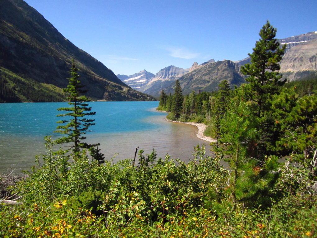
Our first two days were part of the itinerary that got approved and took us on the Gunsight Pass Trail.
Originally we had planned to have four friends accompany us for the first part of our trip so I have tried to schedule a pretty mellow first few days. And then we got our forth choice permit, so as a result day one was still a pretty big day – 11.2 miles and most of it straight up to Sperry Chalet. It was unseasonably hot that day and it was a hard climb, but at the top there was a nice surprise…
Pie and grilled cheese at the Chalet!
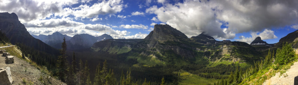
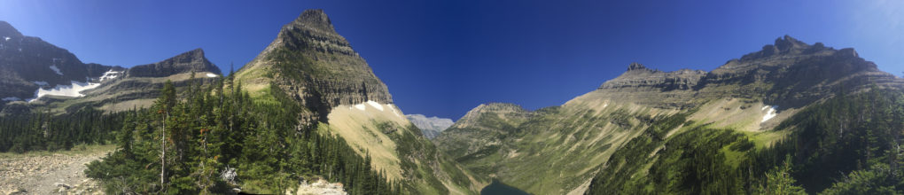
(and this view shortly after from Lincoln Pass.)
After stuffing myself ridiculous on pie we climbed the pass and descended down into the basin of Lake Ellen Wilson.
DAY TWO – Lake Ellen Wilson to Jackson Glacier Overlook (via Gunsight Lake)
Lake Ellen Wilson to Gunsight Lake:
5.0 miles, 1017 elevation gained, 1670 elevation lost
Gunsight Lake to Jackson Glacier Overlook trailhead:
6.2 miles, 500 elevation gained, 500 elevation lost
Day two dawned windy, foggy, and calling for rain. Technically, we were supposed to camp that night at Gunsight Lake but since we had scheduled shorter days for this portion of the trip we decided to push on through and hike all the way back out to the road so that we could drive up to Many Glacier and have a hot shower, pizza, and cider before starting the next part of our hike.
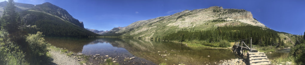
After a short, steep climb up from Lake Ellen Wilson you reach Gunsight Pass.
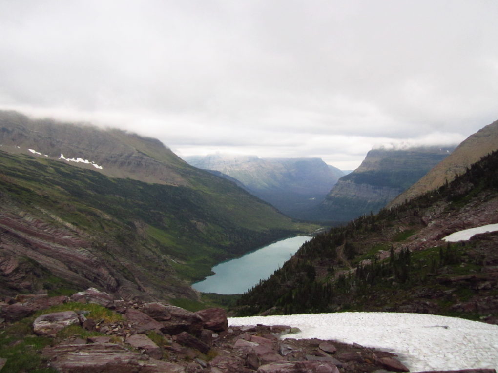
The hike from Gunsight Pass to Gunsight Lake is one of the most beautiful in the park.
DAY THREE – Red Gap Pass Trailhead to Lake Elizabeth
16.6 miles, 3,522 elevation gained, 2415 elevation lost
Day three began with us eating pancakes and drinking tea and being disgruntled.
Our planned route up the Ptarmigan Tunnel, you see, was closed. Apparently a momma grizzly bear and her three cubs had decided it made a great den and refused to move for anyone. This left us with two options – walk 18 miles instead of the planned 10 OR abandon our hike because there was no way that we could get re-permitted for the same route.
So, obviously we decided to walk the extra miles, but that doesn’t mean we had to be happy about it.
Well, it actually turned out to be a beautiful hike despite my bad attitude at the beginning.
We stopped at Poi Lake for lunch on the lake shore before continuing on over Red Gap Pass. The rocks at the pass are a bright red color similar to southern clay because of a mineral deposit.
Little did we know that the adventures were just getting started.
We were finally almost to our destination for the night – Elizabeth Lake – a little before the sun went down. The hike had been much better than I expected, but still I was starting to get tired and hungry and I was ready to be in camp.
We were walking through some heavy woods a little less than a mile from the campground when all of a sudden I came out of the woods into an open meadow – and face to face with a mother moose and her baby.
My brain frantically struggled to remember what you were supposed to do when you encountered a moose – which are notoriously aggressive and unpredictable animals – while I cursed myself for not watching the “how to deal with wildlife video” at the Ranger station all the way through. All of this flashed through my mind in seconds as the moose were maybe 30 feet away. I remembered something about not making eye contact and backed up into the woods again. Once they could no longer see us (moose have terrible eye sight) my husband and I debated what to do.
We sure as hell weren’t turning around and walking 16 miles back to the trailhead so that was out. We tried making noise and throwing a rock to scare the moose off to no avail. Going off trail wasn’t really an option due to the thick underbrush so finally after some deliberation we decided the only option short of staying on the trail all night was to loosen all our pack straps so that they could be dumped if we needed to run and climb up a tree and trying to creep past them.
Carefully we started to sneak past the moose while checking in our peripheral vision if the mother looked agitated. She seemed to be making a point of not looking at us so ever so slowly we creeped on by and several heart pounding minutes later we were past.
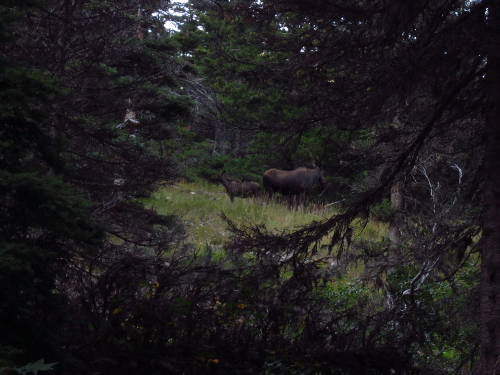
(The baby moose was pretty cute)
As we finally stumbled into the first camp we weren’t really feeling walking two more miles to the camp further down the trail where we had our permit. We decided to sit down at the common area and have dinner and maybe someone would offer to let us share their site for the night and save us the walk. We chatted with the other campers and sure enough, backpackers being awesome folk, someone did offer to let us share their site. After eating we were feeling a bit more energized, though so we decided to go ahead on to our own site.
That lasted all of 10 minutes.
About 800 meters from camp we were walking up the trail with the lake on our left about 10 feet away and a steep slope on our right.
As I topped a little rise something moved in the bushes to our right.
Something BIG.
Appropriately, I squeaked out some obscenity and retreated behind my husband.
Bear spray in hand he edged forward to see if he could tell what it was in the trees because up until now neither of us had seen it.
As he was peering through the bushes about 10 feet from us, up comes a giant gold head with big fluffy ears.
The grizzly bear and my husband made eye contact, and then the grizz sunk back down into the bushes at which point we began to quickly retreat back to camp. We could hear more rustling in the bushes and then about 50 feet above us on the slope we saw a huge grizzly break the tree line…with two baby cubs.
Pretty much the scariest situation imaginable. Thankfully they decided to leave us be and find another place to sleep for the night and so did we.
DAY FOUR – Lake Elizabeth to Mokowanis Junction
10.3 miles, 298 feet gained, 290 feet lost
Day four was a great day – flat and dotted with beautiful lakes.
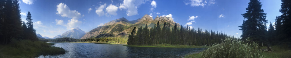
Cosley Lake was my favorite camp site in this part of the park. It is set right on the lake with a nice pebble beach perfect for taking naps.
DAY FIVE – Mokowanis Junction to Kootenai Lake
11.0 miles, 2410 elevation gained, 2975 Elevation lost
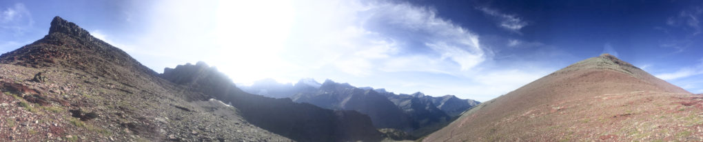
Day five had two nice surprises – Stoney Indian Pass and our campsite at Kootenai Lake.
The entire climb up to Stoney Indian Pass was through this lovely glacial meadow that climbed the valley along a waterfall taking you past hidden lakes and amazing views.
Once you reached the pass it was more of the same.
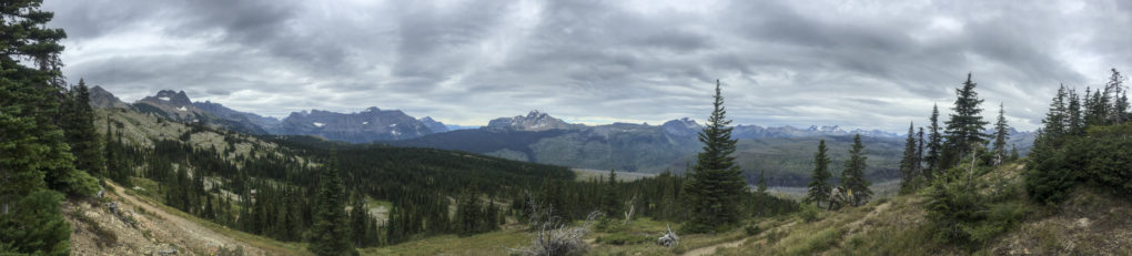
Glacier National Park has a bit of a split personality – it is either blindingly brilliantly blue and sunny or it is gray and misty and mysterious. There doesn’t seem to be much in between. For this hike we were lucky to have the former.
I have to admit, I thought our campsite at Kootenai Lake was going to be terrible. The lake is just 2.5 miles from the Canadian border and generally speaking it is one of the less desirable sites on the Northern Loop.
Well, it is certainly not because of the scenery! If you don’t mind adding 6 miles to your total route this campsite was my favorite of all. We saw a pair of wild swans, bald eagles, and we met the nicest family from Canada. In fact, the company was so good this was the only night on the trail that we stayed up past dark!
DAY SIX – Kootenai Lake to Fifty Mountain
8.3 miles, 2280 elevation gained, 0 elevation lost
Yep, you read that right. We walked uphill ALL DAMN DAY.
That’s all I have to say about that.
DAY SEVEN – Fifty Mountain to Many Glacier (via Granite Park and Swiftcurrent Pass)
Fifty Mountain to Granite Park Chalet
11.9 miles, 1780 elevation gained, 1918 elevation lost
Granite Park Chalet to Many Glacier via Swiftcurrent Pass
7.6 miles, 735 elevation gained, 2255 elevation lost
When we woke up on the morning of day seven it was cold and the forecast was calling for rain by early afternoon so we did what any sane hiker would – decided to wake up early and walk 22 miles back to Many Glacier instead of sleep in 40 degree rain.
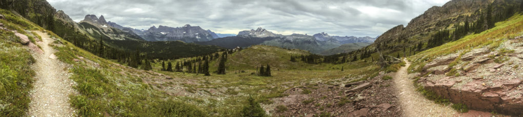
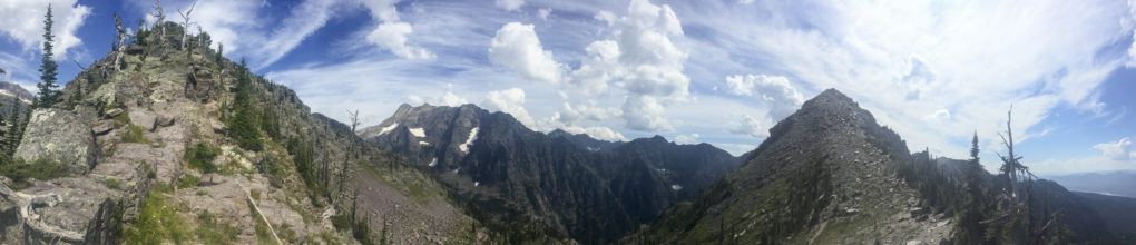
Even though we were pushing pretty hard, this was still one of my favorite days of hiking. The whole day was spent on the Highline Trail, which winds along the side of one range of mountains allowing you views of the adjoining ridges the entire way.
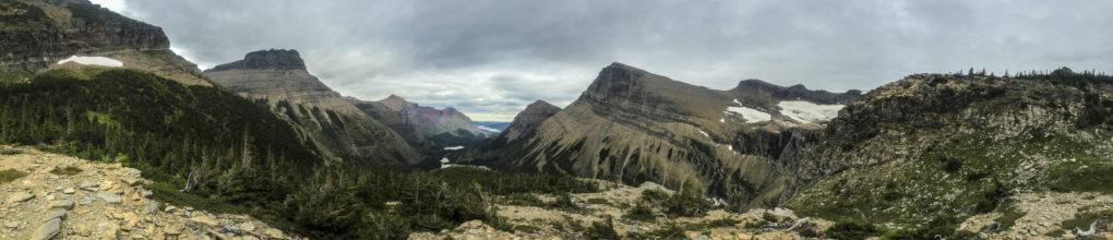
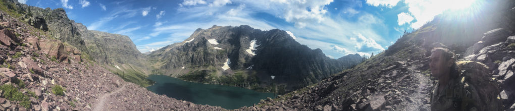
We covered the 12 miles to Swiftcurrent Pass by around lunch time and got to enjoy our last Mountain House to this view (which is one of my favorites in the park).
After lunch it was just a quick 2300 foot decent down Swiftcurrent Pass to a room at the Many Glacier hotel, a hot shower, and an elk steak with my name on it.
Copies of the panoramic images are available for purchase in the Etsy store as posters or canvases! Just click on the images to be taken there…
If you would like to be notified when new items are added to the Etsy shop CLICK HERE and enter your email.


